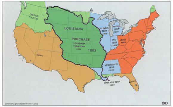
Evolving European and American Conceptions of Louisiana to 1803
Until 1803 the exploration and mapping of the territory acquired by the United States in the Louisiana Purchase was undertaken by the major colonial powers for a variety of reasons. Chief among them was the occupation of the lower Mississippi Valley, as well as the attempted possession of the Great Plains, the Missouri Basin, and the Pacific Northwest. An added incentive was the centuries-old expectation of finding an overland way across the North American continent to the Pacific, with the most desirable route hopefully following the Missouri or one of its tributaries to its westward flowing headwaters, which were believed to empty into the ocean. Once established, that route would enable the command of a vast segment of the North American interior and dominate trans-Pacific trade with the Orient.
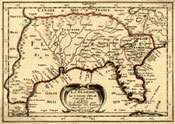
France, Spain, and Britain had separate motives for exploration. France hoped that the less significant rivers, especially those believed to have their origins somewhere in the American southwest, might lead to increased trade with the Internal Provinces of New Spain, as well as to place Spain's claims to lands beyond the Mississippi at defiance. New Spain sought to explore its northern borderlands and develop a barrier to guard against perceived British, French, and, later, American encroachments on territories possessed by the Spanish Crown. Finally, Britain's control over Canada after 1763 was a catalyst for the English-sponsored fur companies and Canadian trappers to push further west over the interior plains in search of beaver and increased commercial contact with the many Native American tribes beyond the Mississippi.
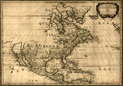
The colonial era maps spawned by those explorations depict, with varying dependability, geographical information about Louisiana's periphery rather than its interior. As conceived by the historical geographer John Logan Allen, the general American view of "the trans-Missouri region on the eve of Lewis's and Clark's trek could best be described as a basin, surrounded by ridges of better knowledge and grading into a vast, flat surface of pure conjecture, broken here and there by a peak of better understanding."
 Of more or less better quality were maps of the Great Bend of the Upper Missouri, which had been reached by British traders from the north and explorers under Spanish patronage working their way up the Missouri from St. Louis. However, that most singular feature of the Missouri River did not begin to take on any recognizable shape, direction, or magnitude on a map until the 1790s.
In preparation for the journey of Meriwether Lewis and William Clark across the continent, President Thomas Jefferson spent the latter half of 1803 and much of 1804 researching the boundaries, extent, terrain, people, and resources of his newly acquired territory. He relied upon his own extensive library, as well as correspondence, reports, and maps from individuals who possessed firsthand knowledge about Louisiana. Jefferson's books and maps on the history and geography of the region, however, were inadequate. The knowledge of his informants was also limited.
One of the more accurate maps that Jefferson gave Meriwether Lewis was prepared as the result of Spanish activities on the Missouri River in the mid-1790s. This map focused primarily on delineating the course of that river as far as the mouth of the Yellowstone. The other map, drawn by cartographer Nicholas King, was a composite based upon both old and new sources that Jefferson and his Secretary of the Treasury, Albert Gallatin, thought would be useful to the expedition. The maps consulted by Jefferson and his colleagues confirmed what was already obvious even to the casual observer Louisiana was terra incognita in want of definition.
RELATED VIDEO


Share this Post
latest post
-
 Louisiana Purchase importance May 1, 2024
 -
 Most important events in US History April 22, 2024
 -
 Movie the Manhattan Project April 18, 2024
 -
 Information on the Louisiana Purchase April 14, 2024
 -
 About World Wars April 10, 2024
 -
 Manhattan Project time travel April 6, 2024
 -
 Manhattan Project hacked April 2, 2024
 -
 Aftermath of World War 1 in American March 29, 2024
 -
 Historical American events March 25, 2024